Images from Wikipedia
The images seen below are from Wikipedia and were obtained under license,
which allows for their legal use on Wikipedia and other websites.
 Attribution: Dosseman, with CC BY-SA 4.0 license, original file:Korykon_Necropoli_and_churches_1242.jpg , Wikipedia
Moving inland from Korykos, for instance from the Land Castle, and then moving to the east visitors will come across many graves, be they rock graves or free standing sarcophagi, and churches. Some of the country can only be reached by foot, sometimes walking along sheep trails, and as the country is hilly one may have to retrace one’s steps from time to time. But it’s most rewarding. Over many visits I have never seen other tourists, just the occasional farmer. I did not manage to identify individual churches, some contributors to Wiki Commons use names like “monastery church”, or “burial church” (whatever that may be) but I do not know on what grounds. So no further description, though some points can be identified when I used gps.
 Attribution: Dosseman, with CC BY-SA 4.0 license, original file:Korykon_Necropoli_and_churches_1247.jpg , Wikipedia
Moving inland from Korykos, for instance from the Land Castle, and then moving to the east visitors will come across many graves, be they rock graves or free standing sarcophagi, and churches. Some of the country can only be reached by foot, sometimes walking along sheep trails, and as the country is hilly one may have to retrace one’s steps from time to time. But it’s most rewarding. Over many visits I have never seen other tourists, just the occasional farmer. I did not manage to identify individual churches, some contributors to Wiki Commons use names like “monastery church”, or “burial church” (whatever that may be) but I do not know on what grounds. So no further description, though some points can be identified when I used gps.
 Attribution: Dosseman, with CC BY-SA 4.0 license, original file:Korykon_Necropoli_and_churches_3270.jpg , Wikipedia
Moving inland from Korykos, for instance from the Land Castle, and then moving to the east visitors will come across many graves, be they rock graves or free standing sarcophagi, and churches. Some of the country can only be reached by foot, sometimes walking along sheep trails, and as the country is hilly one may have to retrace one’s steps from time to time. But it’s most rewarding. Over many visits I have never seen other tourists, just the occasional farmer. I did not manage to identify individual churches, some contributors to Wiki Commons use names like “monastery church”, or “burial church” (whatever that may be) but I do not know on what grounds. So no further description, though some points can be identified when I used gps.
A row of sarcophagi with a church in the distance.
 Attribution: Dosseman, with CC BY-SA 4.0 license, original file:Korykon_Necropoli_and_churches_6987.jpg , Wikipedia
Moving inland from Korykos, for instance from the Land Castle, and then moving to the east visitors will come across many graves, be they rock graves or free standing sarcophagi, and churches. Some of the country can only be reached by foot, sometimes walking along sheep trails, and as the country is hilly one may have to retrace one’s steps from time to time. But it’s most rewarding. Over many visits I have never seen other tourists, just the occasional farmer. I did not manage to identify individual churches, some contributors to Wiki Commons use names like “monastery church”, or “burial church” (whatever that may be) but I do not know on what grounds. So no further description, though some points can be identified when I used gps.
This picture can be taken by just crossing the road passing the Land Castle, and approaching through an orchard.
 Attribution: Dosseman, with CC BY-SA 4.0 license, original file:Korykon_Necropoli_and_churches_6997.jpg , Wikipedia
Moving inland from Korykos, for instance from the Land Castle, and then moving to the east visitors will come across many graves, be they rock graves or free standing sarcophagi, and churches. Some of the country can only be reached by foot, sometimes walking along sheep trails, and as the country is hilly one may have to retrace one’s steps from time to time. But it’s most rewarding. Over many visits I have never seen other tourists, just the occasional farmer. I did not manage to identify individual churches, some contributors to Wiki Commons use names like “monastery church”, or “burial church” (whatever that may be) but I do not know on what grounds. So no further description, though some points can be identified when I used gps.
Here we are above a small group of rock graves across the road from the Land Castle, in the distance we see that at the Island Castle to the right.
 Attribution: Dosseman, with CC BY-SA 4.0 license, original file:Korykon_Necropoli_and_churches_7001.jpg , Wikipedia
Moving inland from Korykos, for instance from the Land Castle, and then moving to the east visitors will come across many graves, be they rock graves or free standing sarcophagi, and churches. Some of the country can only be reached by foot, sometimes walking along sheep trails, and as the country is hilly one may have to retrace one’s steps from time to time. But it’s most rewarding. Over many visits I have never seen other tourists, just the occasional farmer. I did not manage to identify individual churches, some contributors to Wiki Commons use names like “monastery church”, or “burial church” (whatever that may be) but I do not know on what grounds. So no further description, though some points can be identified when I used gps.
 Attribution: Dosseman, with CC BY-SA 4.0 license, original file:Korykon_Necropoli_and_churches_7036.jpg , Wikipedia
Moving inland from Korykos, for instance from the Land Castle, and then moving to the east visitors will come across many graves, be they rock graves or free standing sarcophagi, and churches. Some of the country can only be reached by foot, sometimes walking along sheep trails, and as the country is hilly one may have to retrace one’s steps from time to time. But it’s most rewarding. Over many visits I have never seen other tourists, just the occasional farmer. I did not manage to identify individual churches, some contributors to Wiki Commons use names like “monastery church”, or “burial church” (whatever that may be) but I do not know on what grounds. So no further description, though some points can be identified when I used gps.
 Attribution: Dosseman, with CC BY-SA 4.0 license, original file:Korykos_Land_Castle_1011.jpg , Wikipedia
The entrance to the castle is to the left, this is a computer generated panoramic picture of the front one faces when walking from the heart of modern town.
 Attribution: Dosseman, with CC BY-SA 4.0 license, original file:Korykos_Land_Castle_1112.jpg , Wikipedia
To the south side of the west front there is a jetty that one can walk, then taking pictures back. On some picture we see the front side, on some the southeast side. There is an inlet for what may have been a watergate onder the arch we see, beyond the tower in which its constructed we see the southeast sea side.
 Attribution: Dosseman, with CC BY-SA 4.0 license, original file:Korykos_Land_Castle_1144.jpg , Wikipedia
One of pictures taken while walking along the northeast side of the castle, some of its walls or towers or details there, some of a moat at the southern side.
 Attribution: Dosseman, with CC BY-SA 4.0 license, original file:Korykos_Land_Castle_1154.jpg , Wikipedia
A view along the coastal defensivce works at the southeast side. Getting close with ships must have been near-impossible, as there are rocks in the sea, and huge waves arise regularly.
 Attribution: Dosseman, with CC BY-SA 4.0 license, original file:Korykos_Land_Castle_1172.jpg , Wikipedia
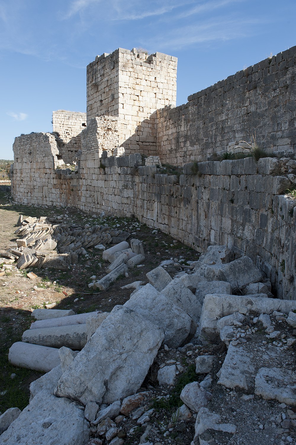
Inside the walls there is a terrain with all sort of buildings, the function of which is partly known but was of little interest to me.
 Attribution: Dosseman, with CC BY-SA 4.0 license, original file:Korykos_Land_Castle_2184.jpg , Wikipedia
A view into the moat. The surrounding country looked quite marshy, and may have been wetter than it is now. The castle itself is to the left.
 Attribution: Dosseman, with CC BY-SA 4.0 license, original file:Korykos_Land_Castle_3238.jpg , Wikipedia
If my memory does not fail me, this is a tower and an inner defensive wall, behind which is the current entrance to the castle. Beyond there is a huge exterior wall, and along part of the northeast side water protects also.
 Attribution: Dosseman, with CC BY-SA 4.0 license, original file:Korykos_Land_Castle_3255.jpg , Wikipedia
Across the road on may see part of the extensive necropolis, with several graves hewn into the rocks and the effigy of a soldier, probably in reference to some grave. One can climb the hill in the back along several roads or pathways, and have this view of the castle. Roaming the hills higher up, particularly to the east, can be very rewarding, as everywhere one comes across rock-hewn graves, as well as freestanding sarcophagi, as well as the remains of several churches, some of them large.
 Attribution: Dosseman, with CC BY-SA 4.0 license, original file:Korykos_Land_Castle_6961.jpg , Wikipedia
Computer generated panoramic view from a "mole of great unhewn rocks [that] projects from one angle of the fortress about a hundred yards [into] [...] the bay. "
 Attribution: Dosseman, with CC BY-SA 4.0 license, original file:Korykos_land_castle_view_from_west_1119.jpg , Wikipedia
A view along the west side. This is taken at the beach in front of the castle. Rounding the last tower to the left one comes to the entrance. From there one can climb into the inner castle, or walk along the inner protective walls all the way round the castle. At several point breaches will allow one to change course.
 Attribution: Dosseman, with CC BY-SA 4.0 license, original file:K%C4%B1zkalesi_to_Ayas_inland_walk_-_Church_of_the_Holy_Sepulchre_as_seen_from_Holy_Street_1219.jpg , Wikipedia
Translated from only a fraction of the precise description in the German Wikipedia, under the lemma "Grabeskirche": "The Church of the Holy Sepulchre, is on the sacred road about 250 meters west of the transept basilica. It is the largest of the churches of Korykos, measuring almost 80 × 30 meters, and its structure is fundamentally different from that of the other church buildings.
If you want to know more, read the German article.


